Hey all! If you’re reading this you’re thinking about joining us this coming Saturday morning for a hike up to the Hollywood Sign.
With that in mind, a couple reminders I just wanted to send your way:
For starters, please review the announcement post for specifics on where to meet, how to get there, parking, attire, distance, duration etc… It’s all very clearly spelled out, but I just encourage people to give it one more read before committing to attend. That way, expectations are fully set 🙂
Also, please let us know you’re coming with an RVSP to our meetup.com group, as that’ll help keep you informed if there’s any last minute changes and also about future events we’re planning.
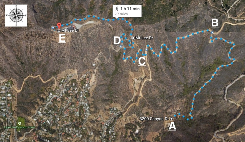
That said, if you’d like to know more about our walk to the Sign on Saturday, I present the following map with some key points along the trail! Hopefully this gives you a clear sense of where we’re headed and how we’re getting there.
A: 3200 Canyon Dr. The trailhead. This is where we meet at 7:15am on 1/31/2015. We depart at 7:30am.
B: The first big fork on the trail. Make sure you turn left here is you’re going to the Sign, otherwise you’ll end up in a grouping of Griffith Park trails towards the east.
C: Second major fork. This will be kind of obvious which way to turn we because you’ll either be able to go uphill to the right or downhill to the left (this will take you over to the Beachwood Canyon trail head). Go to the right!
D: Here you should actually be able to see the side of the Sign. If you turn left here, you’ll end up with a nice view of the front of the sign, but in order to get the top of Mt. Lee directly behind the sign (where we are going) turn right.
E: The trail wraps around to the west after point D on the map and you wind up at our destination, at the summit of Mt. Lee with a glorious view of Los Angeles (and the back of the Hollywood Sign) below.
FYI: Using Your Phone to Map It
You can actually generate a walking map on your phone that you might be able to track your route on, depending on what cell service provider you have, you might be able to use on the trail.
All I do to generate the map is the following process:
- Go to Google Maps App on my phone
- Set your starting point as 3200 Bronson Canyon Dr., Los Angeles California
- Set your destination as “Mt. Lee, Los Angeles, CA”
- Make sure your directions are set to the little walking guy icon and that you choose the route “via Canyon Dr., Mulholland Hwy…”
- The result should look something like what is in the map graphic above, with a distance of around 3 miles.
- If you GPS works up there (it’s hit or miss) you can actually then use this map and the GPS icon to follow yourself up as you hike up to the Sign.
In any case, hope some of this above info is helpful. Looking forward to seeing some folks on Saturday.
Cheers.
advertisements

